GIS Mapping
A geographic information system (GIS) is a system that creates, manages, analyzes, and maps all types of data. GIS connects data to a map, integrating location data (where things are) with all types of descriptive information (what things are like there). This provides a foundation for mapping and analysis that is used in science and almost every industry. GIS helps users understand patterns, relationships, and geographic context. The benefits include improved communication and efficiency as well as better management and decision making. —Esri
Projects

Maximizing Cellular Coverage in Los Angeles County
Viewshed Analysis, April 29, 2020
Analysis of the current cellular coverage in Los Angeles County, California, reveals that 58.2% of the county land area does not currently have cellular coverage. Three scenarios were analyzed to determine which method would be the most cost-effective way to increase cellular coverage in the area.

Starbucks Market Analysis in Riverside, CA
Market & Catchment Area Research Using Network Analysis, April 23, 2020
For this analysis, I determined the service areas that were within a 3-minute drive time of each Starbucks location in Riverside, California. I also conducted an analysis of the Starbucks target market using Census data. 49% of yearly revenue comes from customers that are between the ages of 25-40, and 40% of yearly revenue comes from young adults between the ages of 18-24. The Starbucks locations in Riverside are generally located in areas where the average age of the Census block groups is within this target bracket.

Arkansas’s Hottest and Coolest Cities
Interpolation, April 11, 2020
The following maps show Arkansas’s hottest and coolest cities for the months of January and August as well as climate data for the major cities in the state using two different interpolation methods. Interpolation is a process that calculates a surface of estimated values based off a set of known values of a continuous variable.
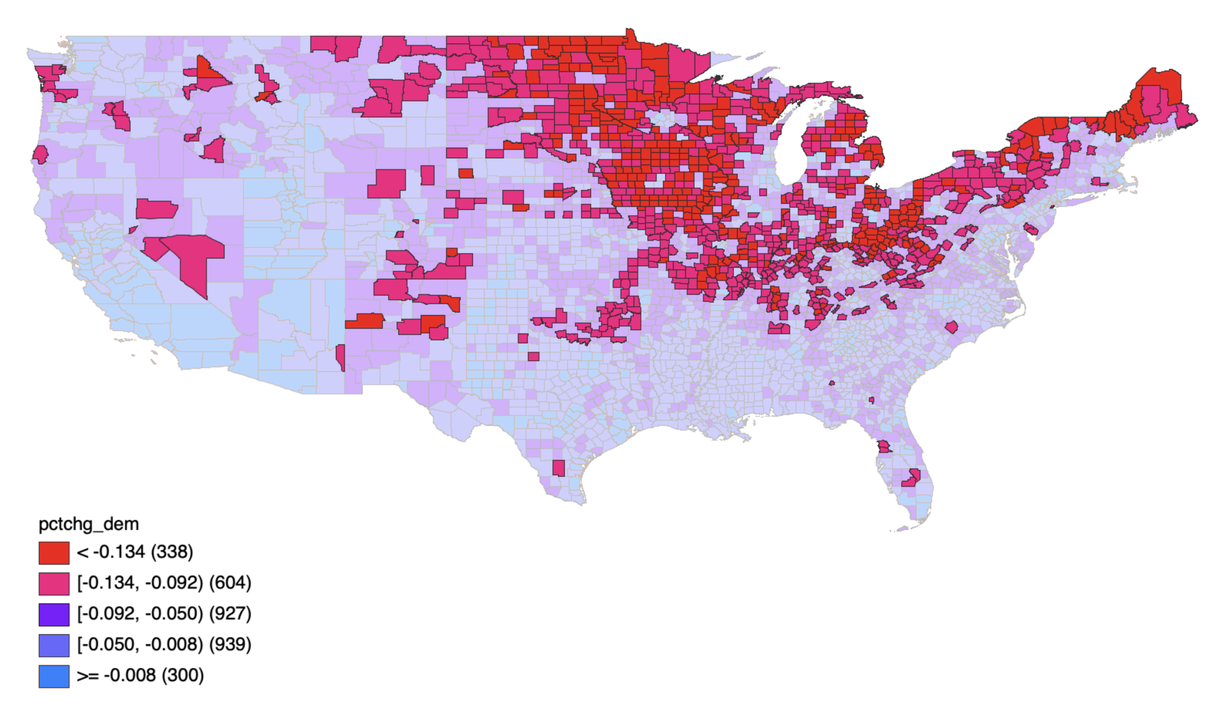
Voting Trends of the 2016 Presidential Election
Spatial Autocorrelation & Geostatistical Analysis, April 1, 2020
In 2016, there was a major shift in the voting trend. Despite allegations of sexual misconduct, questionable business dealings, and racial discrimination, Donald Trump scored a shocking Electoral College victory that won him the 2016 election. Trump and Clinton are considered to be the least-popular nominees on record. Many voters disliked both candidates and opted not to vote at all. So, where did all the support for Trump come from?

Possible Locations for a New Summer Campground in the Laguna & Cuyamaca Mountains
Site Selection, March 3, 2020
In March of 2020, San Diego County retained Angel McVay, to assess possible locations for a summer campground in the Laguna and Cuyamaca Mountains. The objectives of this summary are to provide an overview of the findings and to present recommendations for site selection to the County.